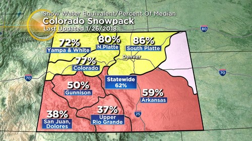
Another blast of cold Arctic air will be backing into eastern Colorado into Monday morning. This will bring a dramatic drop in temperatures and produce areas of snow across the plains back into the mountains.
At this point it looks like the most of the plains including the Denver metro area will have small amounts in the 1 to 2 inch range by the end of Monday morning.
Initially, overnight Sunday into Monday there may be a bit of drizzle mixed with the snow. This could make for somewhat icy commute on Monday morning. There will be higher snow amounts in some of the east facing mountains of the Front Range. With amounts in the 2 to 4 inch range.
One of the bigger things you will notice with this front is the cold. For example our highs in and around the Denver metro area will be in the low 20s. However, these temps will be reached in the morning as temperatures cool into the teens before noon.

Meteorologist Dave Aguilera is a Colorado native and has been forecasting weather in the Rocky Mountain region for over 25 years!